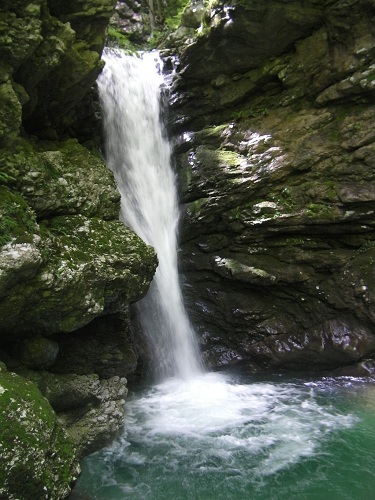
Rio Budrin
Description:
Canyon of only modest interest but nonetheless worthy of decent because of the beauty of the geographical area in which it is located. The descent develops in a wooded area and is characterized by short pitches, jumps, and toboggans.
The canyon is discontinuous but fun, and offers glimpses of considerable charm. The flow rate is usually low but significant flooding is possible, however, the water level subsequently decreases quickly.
During the summer, descent is recommended after a period of rain that has increased the flow.Zone:
Friuli Venezia Giulia - Pulfero (UD)Elevation and length:
Entrance: 627 mExit: 228 m
Height difference: 399 m
Lenght: 2000 m
Highest pitch: 30 m
Advised decent period:
From May to OctoberExposure:
East - SouthEastTimings:
Approach: 10 mins / 1h 10 minsDescent: 6h
Return: 10 mins
Shuttle:
15 km Anchors:
InsufficientAdvised ropes:
1 of 60 m, 1 of 30m + emergency ropeGear:
Complete wetsuit, bolting kitEscapes:
There is the possibility to exit from the streambed in several places on the left side, where the path n° 735 can be intercepted after a difficult climb up this bank.Map:
Carta Tabacco 1:25000 foglio n° 041 - Valli del NatisoneInterest:
LocalDifficulty:
V3 A2 IICoordinates (WGS84) for downstream (valley) parking:
46° 12' 03,3" N 13° 28' 14,9" ECoordinates (WGS84) for access point of the path n° 735:
46° 12' 02,1" N 13° 28' 12,1" ECoordinates (WGS84) for upstream (mountain) parking:
46° 11' 55,6" N 13° 26' 33,0" ECoordinates (WGS84) of the riverbed access point (start of canyon):
46° 11' 38,1" N 13° 26' 29,4" EApproach to the valley (lower car park):
From Cividale, take the SS 54 in the direction towards Slovenia.
Arrive in the village of Stupizza, immediately after the first houses take the dirt road on the left.
Follow this road until you arrive near a bridge (not passable by car) that crosses the River Natisone. Leave your car in the small clearing before the bridge.Approach to the mountain (without shuttle):
Cross the bridge and take the path n° 735 that leads towards Montefosca.
The trail reaches a tarmac road that you follow until you enter the village of Montefosca. Between the houses, towards the left, the path restarts. Descend on the path through the woods until you arrive at an ancient bridge crossing the Rio Budrin. Enter the canyon.Approach to the canyon (with shuttle):
With the second car, turn back towards Cividale. At Loch-Linder, turn right towards Montefosca.
Once in Montefosca, turn right in the direction of the church. Immediately after the church steeple, turn left and leave the car in front of the church. From here, walk up towards the village. Find the path between the houses and follow it for 10 mins to reach the bridge over the Rio Budrin. Enter the canyon.If you want to drop-off the equipment closer to the canyon, instead of turning after the steeple you can continue on the forest road (prohibited), initially on asphalt that then turns to a dirt track, until you reach a bridge and crossroads where you drop-off the equipment.From here, the start of the canyon is a 5 min walk, near the ruins of an old mill.
Description and technical notes:
The canyon starts with a small jump and a sequence of two pitches that continue into alternating zones of open and closed meandering canyon passages, until the highest pitch is found below a large rock arch. The canyon continues with pitches and jumps located between alternating walking and short narrow passages.01 - J 2
02 - NA R 8
03 - P 8 (by-passable L)
04 - P 6 L
05 - T 5
06 - J 2
07 - P 15 L
08 - P 30 L
09 - P 6 R / possible j 6
10 - P 8 R
11 - J 4
12 - T 6 / possible j 3 on the R
13 - NA 10 L
14 - J 6
15 - P 8 L
16 - P 12 R
17 - NA 6 R
18 - P 8 R / possible J 6
19 - J 2
20 - MC NA + P 10 R
Exit:
After the last pitch, follow the river until you find an exit point from the riverbed on the left bank.
After a short walk, you intercept faint traces of a path that becomes increasingly visible. Follow the path alongside the stream, that becomes gradually further away, and eventually leads to the meadows near the visitor centre "The house of the bears" ("La casa degli orsi"). Continue to the bridge and cross over the River Natisone. Follow the path until you reach the car.Notes:
The first descent was made between 1990 and 1995 by Pier Carlo Toffoletti and Maurizio Balutto, together with members of the speleological group "Forum Julii Speleo" of Cividale.Descent is recommended after periods of rain, as the canyon is often dry or with minimum flow. To check the water level, follow the description above for the exit, in reverse order, until you can verify the water level of the last waterfall. Many pitches are by-passable by cutting through the woods.
URL:http://www.canyoneast.it
Layout, design & revisions © 2017, CanyonEast Canyoning Team - Seba Broili, Vanessa Johnston, Romy Siegl, Cristian Vogrig
Webmaster: uomonero@canyoneast.it - Revised - - 22/08/2017
Layout, design & revisions © 2017, CanyonEast Canyoning Team - Seba Broili, Vanessa Johnston, Romy Siegl, Cristian Vogrig
Webmaster: uomonero@canyoneast.it - Revised - - 22/08/2017


