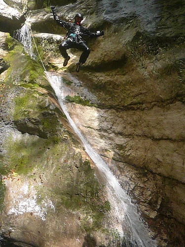
Rio Cunaz
Description:
A short but very beautiful canyon. The first section is in a closed environment between high walls with a continuous sequence of pitches, whereas the second
section is more open and passes through the woods. There are many opportunities for jumping and tobogganing.Zone:
Friuli Venezia Giulia - Budoia (PN)Elevation and length:
Entrance: 750 m Exit: 450 m
Height difference: 300 m
Length: 800 m
Highest pitch: 25 m
Advised decent period:
From May to OctoberExposure:
WestTimings:
Approach: 50 mins Descent: 2 h
Return: 10 mins
Shuttle
NoAnchors:
Insufficient / SufficientAdvised ropes:
1 of 60 m + emergency ropeGear:
Full wetsuit and bolting kitEscapes:
Only in the second part Map:
Carta Tabacco 1:25000 foglio n° 012 - Alpago - Cansiglio - Piancavallo - ValcellinaInterest:
RegionalDifficulty:
V3 a1 IICoordinates (WGS84) for downstream (valley) parking:
46° 4' 14,0" N 12° 30' 38,0" ECoordinates (WGS84) for the start of footpath CAI 990A and 994:
46° 4' 16,5" N 12° 30' 33,9" ECoordinates (WGS84) of the riverbed access point (start of canyon):
46° 4' 54,2" N 12° 30' 55,9" EApproach to the valley (lower car park):
From Aviano, follow the SP29 towards the village of Dardago. Immediately after passing the signpost for the entrance to the village, take the first road on the
right (via Rivetta) and follow it for about 4 km. Park near the restaurant "Lo Chalet".Approach to the canyon (walking):
Continue to walk down the road that soon becomes a forest track, and whose first stretch coincides with footpath CAI n° 990A and n° 994. You reach a barrier
(100 m) that prevents unauthorized vehicles from passing through. Continue on until a fork (signed "sentiero della memoria") where you continue towards the
right along the path n° 994.This climbs continuously, crossing the forest road several times and, in some parts, also follows this road. In one of these parts, there is an obvious and wide hairpin bend to the left; from where you can inspect the initial part of the canyon from above. From this point, you leave for the last time the forest road, continuing on the CAI path that runs along the right bank of the canyon.
Shortly after, take an obvious track on the right that leads to the riverbed, from where the canyon begins.
Description and technical notes
The canyon narrows immediately between high walls and a slight decline leads to the first toboggan01 - T 3
02 - P 8 L
03 - P 10 L possible T/J 8
04 - P 8 L
05 - T 6
06 - P 20 (12+8) L possible T/J 8
07 - P 15 R
08 - P 8 R
09 - T 4
10 - P 6 L
11 - P 25 R
Continue for about 200 m down climbing between large rock blocks
12 - T 4
13 - T 3
14 - P 10 L
15 - T 3
16 - T 3
17 - P 10 L possible J 6
18 - J 4
Exit:
After the last jump, you reach a weir. From here, go up the left bank of the river and intercept a road that soon leads to the car park.Notes:
Data on the first descent are unknown.URL:http://www.canyoneast.it
Layout, design & revisions © 2017, CanyonEast Canyoning Team - Seba Broili, Vanessa Johnston, Romy Siegl, Cristian Vogrig
Webmaster: uomonero@canyoneast.it - Revised - - 22/08/2017
Layout, design & revisions © 2017, CanyonEast Canyoning Team - Seba Broili, Vanessa Johnston, Romy Siegl, Cristian Vogrig
Webmaster: uomonero@canyoneast.it - Revised - - 22/08/2017


