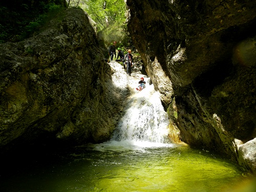
Rio Favarinis
Description:
The Rio Favarinis is the only river of the south slope of Mount Amariana with a consistent flow of water, which runs through a beautiful gorge before its confluence with the River Fella. The gorge is cut in rocks of the Triassic period, called the Dolomia Principale, that form the base of Mount Amariana.On the inner walls of the gorge it is easy to find fossils of the bivalve megalodon that have a characteristic heart-shaped cross-section. The steep slopes that flank the canyon are covered with thick pine forests of black pine (Pinus negra).
It is an easy route suitable for beginners. Particularly noteworthy is the beautiful emerald green colour of the clear water in the pools.
Zone:
Friuli Venezia Giulia - Amaro (UD)Elevation and lenght:
Entrance: 520 mExit: 270 m
Height difference: 250 m
Length: 500 m
Highest pitch: 50 m
Advised decent period:
From May to OctoberExposure:
SouthTimings:
Approach: 40 minsDescent: 2h 30 mins
Return: 5 mins
Shuttle:
NoAnchors:
ExcellentAdvised ropes:
2 of 50 m + emergency ropeGear:
Full wetsuitEscapes:
On the left bank there are likely to be some possible exits (to be checked); before the last pitch there is a clear track allowing you to by-pass it.Map:
Carta Tabacco 1:25000 foglio n° 013 - Alpi Carniche, Val TagliamentoInterest:
LocalDifficulty:
V4 a2 IIICoordinates (WGS 84) for upstream (mountain) parking and access point of the path CAI n° 415:
46° 23' 8.16''N 13° 7' 15.24''ECoordinates (WGS 84) where you leave the path CAI n° 415:
46° 23' 17.52''N 13° 7' 3.36''ECoordinates (WGS 84) of the riverbed access point (start of canyon):
46° 23' 13.92''N 13° 6' 45.36''EApproach to the valley (lower car park):
Take the motorway exit "Carnia-Tolmezzo" and follow the signs towards Tarvisio. Continue for approximately 4 km and, immediately before passing under the motorway viaduct, you take a small road on the left that quickly leads to the bridge over Rio Favarinis, after which there is an open space for parking.Approach to the canyon (walking):
Take the path CAI n° 415 and follow it up until you find some ruins of a building on the left (about 30 mins). Continue on the main path for a few tens of meters until a trail branches off to the left (marked with white and red paint on trees). Follow this trail until you reach a slope leading towards the canyon, where the last part is a steep descent through the trees to reach the riverbed.Description and technical notes:
n.7 - P 12 R + DEV R (or P 10 L)T 2 or J 4 (by-passable R)
n.6 - MC + P 30 R (or P 30 L)
Progression of about 150 m with some small downclimbs
n.5 - P 8 L (by-passable L)
Progression of about 150 m with some small downclimbs
n.4 - P 12 R + DEV R (or P 12 L)
n.3 - P 3 L
n.2 - MC + P 20 R
J 2 (by-passable R)
n.1 - MC + P 50 R
At the base of the last pitch there are 2 anchor points that can be used for a Tyrolienne (in which case 2 × 60 m ropes are required).
Exit:
At the end of the canyon, the riverbed opens out and the bridge becomes visible. After several metres walking, a path on the left can be followed up to the car park.Notes:
The first descent was made in August 1996 by M. Biondi, C. Stavagna, S. De Rossi and F. Cernjgoi.URL:http://www.canyoneast.it
Layout, design & revisions © 2017, CanyonEast Canyoning Team - Seba Broili, Vanessa Johnston, Romy Siegl, Cristian Vogrig
Webmaster: uomonero@canyoneast.it - Revised - - 22/08/2017
Layout, design & revisions © 2017, CanyonEast Canyoning Team - Seba Broili, Vanessa Johnston, Romy Siegl, Cristian Vogrig
Webmaster: uomonero@canyoneast.it - Revised - - 22/08/2017


